After Northeasterners woke up to a coating of powdery snow and a fresh round of frigid air on Friday morning, a more potent winterlike storm is looming for the region.
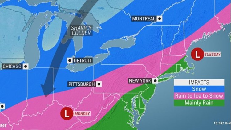
The next storm will first gather in the center of the country late this weekend, bringing snow from Montana to the central and southern Plains. It may then set its sights on the Ohio Valley and Northeast early next week, bringing yet another round of wintry weather.
With the storm expected to take a quick jog to the east, snow will start for many in Indiana, Ohio, Michigan and western New York first thing on Monday morning.

"The major impacts of the storm will be largely determined by the storm track," AccuWeather Meteorologist Nicole LoBiondo said.
A more northerly storm track would shift the heaviest snowfall totals into Canada and will make it harder for snow to fall across coastal locations in the Northeast.
However, at this time, the center of the storm is forecast to shift from Kentucky early on Monday to southern Maine by Tuesday.
In this scenario, precipitation for coastal Maine through Pennsylvania and down to Kentucky may start off as rain. However, plummeting temperatures throughout the afternoon Monday and into Monday night as the storm moves through will allow precipitation to transition to an icy mix then eventually snow.
Freezing rain and snowfall could cause a tricky commute for motorists who travel on parts of Interstates 70, 76, 80, 81, 86, 87, 90 and 476 on Monday afternoon and evening.
"The changeover to wintry precipitation and the heavy snow farther north will likely cause a travel nightmare for many in the Northeast into Tuesday," LoBiondo added.
Widespread snowfall amounts of 1-3 inches are expected from Indiana into southeastern Canada, with amounts of 3-6 inches expected to stretch from northeastern Ohio to northern Maine.
However, AccuWeather meteorologists expect a swath of higher snowfall totals from central New York to northern Maine, where accumulations could climb into the double digits with an AccuWeather Local StormMax™ of 18 inches.
"The heaviest snow will likely be concentrated on the northeastern side of the storm," LoBiondo said, adding that snow will pile up most as the speed of the storm slows down.
With snow likely to start in northern New York and northern New England on Monday and continue into early Tuesday, this is the most likely location for the highest snowfall totals.
Mainly rain is predicted for the major I-95 cities from Washington, D.C., to Philadelphia and New York City; however, cold air may rush in and allow some flurries to develop at the end of the storm.
By Tuesday morning, a stiff cold wind and lingering flurries are likely across much of the Northeast while the steadiest snow is expected to persist in northern New England.
Brutally cold air will arrive in the wake of the storm, with low temperatures across much of the Ohio Valley and the Northeast forecast to dive down into the teens on both Tuesday and Wednesday mornings.

This cold air rushing over the warmer waters of the Great Lakes will also to create some lake-effect snow early next week.
Northerly winds will generate snow south of Lake Michigan and Lake Superior as early as Monday afternoon. The wind direction should become a little more northwesterly by Tuesday morning, and lake-effect snow may be triggered downwind of Lake Huron, Lake Erie and perhaps Lake Ontario.
Because of the extended duration of lake-effect snow, the highest totals from that event will be likely in parts of Michigan and northern Indiana. The close proximity to the storm traveling through the Northeast may prevent the higher piles of lake-effect snow from developing in the eastern Great Lakes.
The high pressure bringing in the cold will spell dry weather for most of the region during the middle of the week. The high will also shut off the lake-effect snow by Wednesday morning.
Download the free AccuWeather app to track the wintry weather headed for your area. Keep checking back for updates on AccuWeather.com and stay tuned to the AccuWeather Network on DirecTV, Frontier and Verizon Fios.