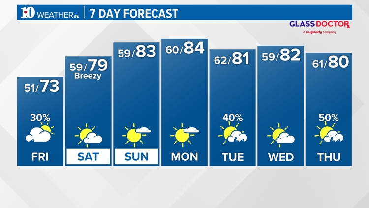
WBIR Forecast
Weather News
- A chance for passing showers Friday morning, then drying into afternoon
- New color-coded heat risk tool adds a level higher than red
- Strawberry season is ripe for the picking!
- Lyrid meteor shower: When is the peak, where to look in the sky
- Great American Eclipse turns out no-so-great for cloud-covered East Tennessee
- Here's what time the solar eclipse will begin in Tennessee
10-Day Forecast
Fri
Apr 26
73
59
30%
5
MPH
E
Morning showers. Highs in the low 70s and lows in the upper 50s.
71%
Moderate
6:48 AM
8:18 PM
Sat
Apr 27
79
59
0%
9
MPH
SSW
Considerable cloudiness. Highs in the low 80s and lows in the upper 50s.
54%
Moderate
6:46 AM
8:19 PM
Sun
Apr 28
83
60
0%
7
MPH
SW
More sun than clouds. Highs in the mid 80s and lows in the upper 50s.
52%
Very High
6:45 AM
8:20 PM
Mon
Apr 29
84
62
0%
9
MPH
SW
A few clouds. Highs in the mid 80s and lows in the low 60s.
51%
Very High
6:44 AM
8:21 PM
Tue
Apr 30
81
59
40%
7
MPH
SW
Showers ending by midday. Highs in the low 80s and lows in the low 60s.
67%
High
6:43 AM
8:22 PM
Wed
May 01
82
61
0%
6
MPH
SW
Mix of sun and clouds. Highs in the mid 80s and lows in the low 60s.
63%
Very High
6:42 AM
8:23 PM
Thu
May 02
80
57
50%
7
MPH
WSW
Showers and thunderstorms late. Highs in the low 80s and lows in the low 60s.
64%
Very High
6:41 AM
8:23 PM
Fri
May 03
73
57
20%
6
MPH
W
Showers. Highs in the mid 70s and lows in the upper 50s.
66%
High
6:40 AM
8:24 PM
Sat
May 04
78
54
40%
7
MPH
NW
Plenty of sun. Highs in the upper 70s and lows in the mid 50s.
56%
Very High
6:39 AM
8:25 PM
Sun
May 05
80
58
21%
5
MPH
W
Times of sun and clouds. Highs in the low 80s and lows in the upper 50s.
53%
Very High
6:38 AM
8:26 PM
Hourly Forecast
5 AM
Fri
52°
20%
3
MPH
ENE
6 AM
Fri
52°
0%
4
MPH
NNE
7 AM
Fri
51°
0%
4
MPH
NE
8 AM
Fri
52°
0%
4
MPH
NNE
9 AM
Fri
57°
0%
3
MPH
ENE
10 AM
Fri
62°
0%
4
MPH
SE
11 AM
Fri
65°
20%
5
MPH
SSW
12 PM
Fri
67°
20%
5
MPH
SSW
1 PM
Fri
69°
20%
6
MPH
SSW
2 PM
Fri
71°
20%
8
MPH
SSW
3 PM
Fri
72°
20%
9
MPH
SSW
4 PM
Fri
73°
20%
9
MPH
S