
SEVIER COUNTY, Tenn. — People in Southern Sevier County received a warning on their phone Monday afternoon as officials worked to make sure everyone was aware of the extreme fire threat across the area.
The Sevier County Emergency Management Agency sent out an IPAWS alert at 4:00 p.m. Monday for the Red Flag Warning that's in effect for the southern portion of the region. IPAWS is the same system used to send out severe weather alerts and AMBER Alerts to the public via phones.
Red Flag Warnings are issued by the National Weather Service and are intended to warn people that extremely windy, dry conditions are present that can ignite brush fires that can rapidly spread out of control. People across Tennessee are being told not to burn anything outdoors right now.
Winds will increase across the area through the rest of the day with peak gusts expected from midnight tonight into Tuesday afternoon.
The strongest winds will occur in the Foothills and Mountains along the Tennessee/North Carolina state line. A High Wind Warning is in effect until Tuesday afternoon for wind gusts up to 70 to 80 mph possible in elevations above 2,500 feet.
Areas under a Red Flag Warning are shaded in red below:

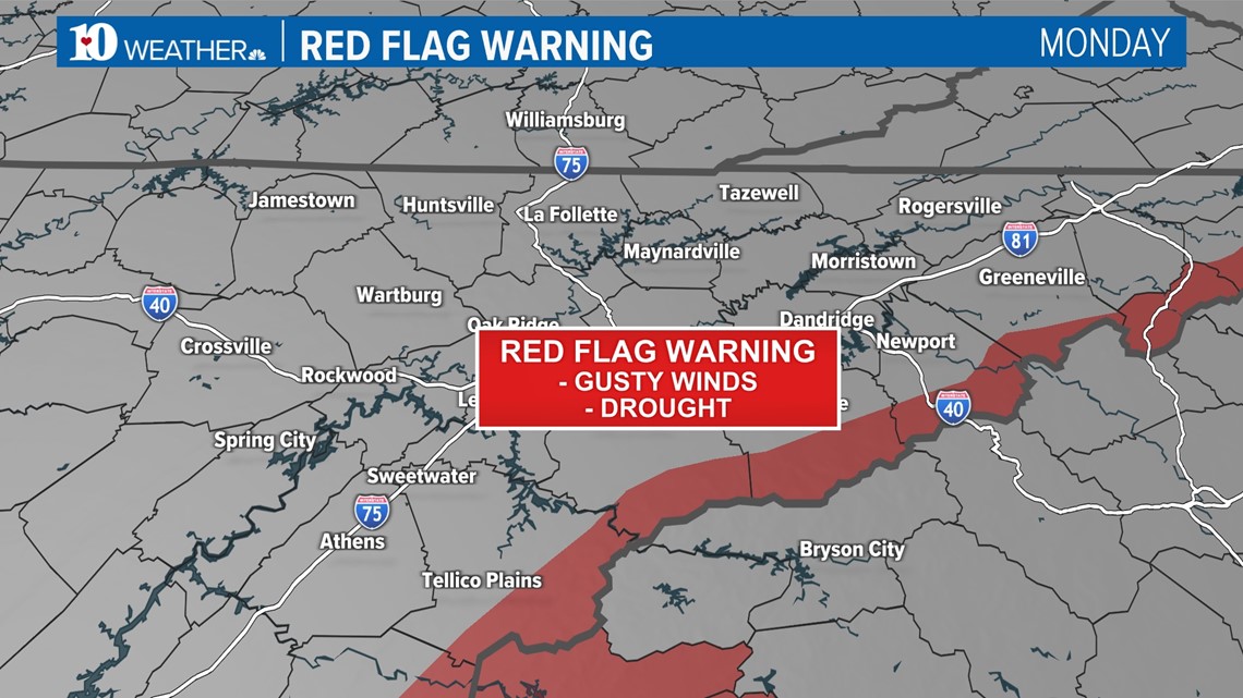
Due to the ongoing drought conditions, the fire danger will be extremely high across the entire viewing area. Fires will be able to develop easily and spread very quickly in these conditions. If you live near an ongoing fire or start to see smoke, it may be a good idea to have a "go bag" ready in case you need to evacuate the area with short notice.
Sevier County Electric System said it cut power to some parts of the GSMNP Monday out of precaution in order to prevent downed electrical wires from sparking up fires. That area included Elkmont and Metcalf Bottoms.
"As forecasted, the wind is coming across the mountains and dropping in, that'll be the first place it'll hit. So we picked those and it's the, it impacts the least amount of people," Allen Robbins, CEO of SCES said.
The CEO said more populated areas like Townsend and Gatlinburg have put other safety precautions in place.
"We actually met last night to discuss how we're responding, what we're going to do. We met again this morning with the National Weather Service to get a briefing. So, we met with all the EMA personnel, fire chiefs, police departments, and county mayors. And so, we were trying to be as proactive as you possibly can," he said.